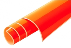
Gliderchart South France 2023

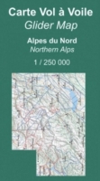
“Alticarte” map
A map that (finally) shows the landscape, restricted zones and airfields with altitudes and frequencies, outlanding areas indexed in the catalog, turning points.
It covers the French Alps from Fayence to Chambery and from the Italian border to Aubenasson (Diois).
Scale :1:250 000
Customers who bought this product also bought the following products:

%
Our previous price 16,90 EUR
Now only 13,90 EUR
you save 18 % /3,00 EUR
1,39 EUR per mNow only 13,90 EUR
you save 18 % /3,00 EUR
19 % VAT incl. excl. Shipping costs

from 1,80 EUR
unit price 2,20 EUR
0,11 EUR per munit price 2,20 EUR
19 % VAT incl. excl. Shipping costs

from 2,00 EUR
unit price 2,40 EUR
0,12 EUR per munit price 2,40 EUR
19 % VAT incl. excl. Shipping costs


from 21,00 EUR
unit price 26,00 EUR
26,00 EUR per lunit price 26,00 EUR
19 % VAT incl. excl. Shipping costs